Our Coast Resources
Bellarine Peninsula - Corio Bay Local Coastal Hazard Assessment - Summary Report (e-Magazine format)Bellarine Peninsula - Corio Bay Local Coastal Hazard Assessment Requires Flash Player browser plugin |
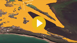
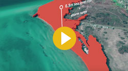
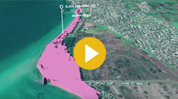
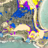
Bellarine Peninsula - Corio Bay Local Coastal Hazard Assessment Inundation - Summary ReportOur iconic coastlines are shaped by wind and waves and are changing over time. These changes influence the way we work, live, play and relax on the coast. There is consensus amongst scientists now that our climate is changing as a result of global warming. Some of the effects we are likely to experience in the future are higher temperatures, changes in rainfall patterns, a rise in sea level, an increase in the magnitude and frequency of coastal storms and as a result, more frequent inundation of low-lying coastal areas. This is likely to have adverse effects not only on infrastructure and the built environment but also the natural, cultural and social environment. We therefore need to adapt to changes we or our children are likely to experience in the future. As such, we need to start planning for the future now and want you to be involved!
|
Bellarine Peninsula - Corio Bay Local Coastal Hazard Assessment - Full ReportCardno was commissioned by the City of Greater Geelong (CoGG), the Department of Sustainability and Environment (DSE) (now the Department of Environment and Primary industries (DELWP), the Corangamite Catchment Management Authority (CCMA), the Department of Planning and Community Development (now part of DELWP) and the Borough of Queenscliffe (BoQ) to undertake the Bellarine Peninsula - Corio Bay Local Coastal Hazard Assessment (Bellarine Peninsula - Corio Bay LCHA). These organisations make up the Project Control Group (PCG). This study is one of four Local Coastal Hazard Assessments undertaken in Victoria through collaborative partnerships with local stakeholder agencies and was initiated through the DSE (now DELWP) Future Coasts Program. A web-accessible HTML version of the full report is also available
|
Risk Methodology ReportThis document outlines the methodology used to complete the coastal climate risk assessment associated with the Geelong – Queenscliffe Coastal Adaptation Program. The project was completed over an 18 months timeframe from inception in April 2015 to June 2016.
|
Coastal Inundation Options ReportThe pressure on our coastal areas is continually increasing. The population of the wider Geelong region (G21 area) increased by nearly 20,000 people between 2006 and 2011, and over the next 20 years the City of Greater Geelong's population is forecast to increase by more than 35% (ID Consulting, 2015). Many of these people are attracted to the region by the relaxed coastal lifestyle on offer with its ready access to major population centres. This increased population will increase demand for access to coastal areas and resources, and intensification of residential and commercial development on coastal fringes. As a consequence, existing and future communities need to be prepared to respond to the threat of coastal inundation hazards of sea level rise, storm tide, coincident catchment flooding and wave overtopping.
|
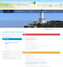
Coast Impact Solutions ToolCoastal impact solutions tool. List possible solutions by asset type and grouped by solution type (retreat / adapt / maintain status quo). |
City of Greater Geelong & Borough of Queenscliffe Flood Adaptation Effectiveness StudyThe City of Greater Geelong and Borough of Queenscliffe (these together will be called CoGG for brevity here on in the report) in Victoria are situated on the Bellarine Peninsula with coastlines on Corio Bay, Port Phillip Bay and Bass Strait.
|